
Navigating Winter’s Challenges: A Weather Update
As winter sets in, road conditions become a major concern for commuters and travelers alike. Our current weather data indicates that many roads are damp, with patches of snow and slush, creating potentially hazardous driving situations. This is primarily due to the application of brine and salt, which effectively lowers the freezing point of water. Even at temperatures hovering around minus one degree Celsius, the combination of melting conditions can lead to deceptively slick surfaces.
While road crews have taken steps to treat many highways, not all pathways have received similar care. Sidewalks, in particular, may still present challenges, as untreated surfaces can become slippery. A word of caution: take extra time to brush off your vehicle before setting out. The discrepancy in road conditions could catch drivers off guard, especially as they transition from treated highways to untreated side streets.
Feeling colder than the thermometer indicates, the current weather feels like minus five degrees Celsius, thanks to the chill factor. However, there’s a glimmer of hope in the forecast. As we look forward, temperatures are expected to rise slightly above the freezing mark later in the day. The coldest air is now settled in the eastern prairies and northwestern Ontario, while a southwesterly wind is ushering in warmer air. This transition keeps us in the seasonal temperature range, close to the normal high for this time of year.
Beyond the immediate weather changes, radar images show a snow system retreating to the east. Still, there remains a minor risk of sporadic flurries, which, while not heavy, could add another layer of slickness to the roads. These minimal snow patches will likely manifest as wet flurries during daylight hours, given the warmer temperatures expected.
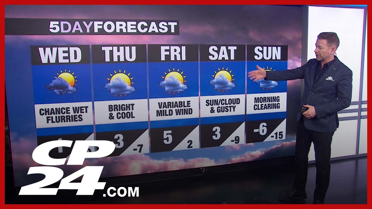
Looking at the broader forecast, there’s an anticipated spike in temperature as we approach the weekend. With Wednesday’s high reaching one degree Celsius and only a slight chance for occasional wet flurries, conditions will begin to feel less severe. Yet, a cool wraparound wind could serve as a reminder that winter is not done with us yet.
As we progress to Friday and Saturday, the promise of milder weather emerges. Forecasts predict a high of five degrees Celsius on Friday, accompanied by gentle winds. This mild shift may be an ideal opportunity for individuals to engage in outdoor activities or complete tasks that have been delayed due to the weather.
However, as we glance toward Sunday, reality sets in once again. Despite the temptations of a mild Saturday, temperatures are poised to drop significantly, plunging back to minus six degrees and possibly down to minus fifteen by Sunday evening. This shift signals the return of colder Arctic air, reinforcing the need for residents to prepare for another wave of winter’s chill.
In sum, while it appears the rest of the week offers a mix of challenging conditions and slight reprieves, planning ahead remains essential. Acknowledging and adapting to the fluctuating weather will not only promote safer travel but also ensure that residents can make the most of the brief warm spells. Whether it’s brushing off the car, planning activities around the forecast, or simply remaining attentive to changing conditions, awareness is key to navigating the complexities of this winter season.