
The Coming Weather Systems: What to Expect This Week
As winter progresses, meteorologists often find themselves sifting through a monotonous routine. The cold, calm, and clear days can feel tedious. However, the arrival of warmer air brings with it a renewed interest in weather patterns. This week, a shift is on the horizon, signaling a significant change in atmospheric conditions.
Currently, temperatures are fluctuating between -7°C and a milder high of +4°C. This increase is courtesy of a warm air mass moving in from the southern United States. Yet, the cold hasn’t completely receded. This juxtaposition of warm and cold air creates instability in the atmosphere, setting the stage for various weather systems to impact our region.
Anticipating the Storms
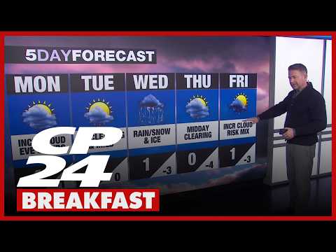
On Wednesday, confidence is high that a complex storm system will affect our area. The day is expected to begin with a mix of weather conditions, from snow to freezing rain, potentially culminating in rain later in the day. Meteorological data suggests that snow accumulations could range from 10 to 20 centimeters, particularly if the storm delivers more snow than other forms of precipitation. However, a mixed bag of rain and ice would reduce snowfall totals but increase the risk of hazardous road conditions.
The storm is expected to start making its presence felt in the early hours, around 3:00 a.m., and continue through to the dinner hour. Initial forecasts indicate that conditions will be messy from the outset, impacting travel and daily routines. Given the unpredictable nature of winter weather, it’s advisable to exercise caution during this period.
Clearing and Subsequent Systems
Following Wednesday’s storm, the forecast indicates midday clearing on Thursday, with a high temperature plateauing at zero degrees Celsius. This brief respite will mitigate some of the challenges presented by the storm, allowing for potential recovery in terms of road conditions.
As the week progresses, Friday could present another system, albeit a lighter one, which may bring some mixed precipitation. However, details regarding this system remain uncertain, as current models show a lack of consensus about its strength and timing. This uncertainty extends into the weekend, compelling a need for ongoing updates as meteorologists continue to analyze incoming data.
Staying Informed
In such dynamic weather scenarios, keeping abreast of the latest forecasts is crucial. Weather conditions can change rapidly, especially in the transitional period where cold air meets warmth. It’s important to stay tuned to updates, especially when the models aren’t in complete agreement.
The interplay of the varying air masses not only complicates the forecast but also presents an intriguing aspect of meteorology. There’s a balance to be struck and a careful dance between cold and warm air that will determine not just the weather of the coming days, but also how the conditions will play out on the ground.
Conclusion
In conclusion, this week promises a blend of weather phenomena brought about by the arrival of warmer air and the lingering effects of winter’s chill. The tumultuous interplay of these air masses will produce a series of events worth observing. While calm and clear winter days may have their own charm, the exciting potential for winter weather here is inherently compelling. As we prepare for the changes ahead, remember that staying informed is your best strategy—adapt accordingly, and you’ll navigate whatever this week throws your way.