
Navigating the Evolving Winter Weather in the Greater Toronto Area
As the Greater Toronto Area (GTA) braces for significant winter weather changes, forecasters and transportation officials are urging residents to stay informed and prepared. Current reports indicate a storm alert due to shifting weather patterns characterized by a mix of rain, freezing rain, and wet snow. Understanding these dynamics is crucial as they evolve throughout the day.
This morning, the conditions appeared relatively calm. Reports from various parts of the GTA highlighted minimal precipitation, with only light rain falling in areas like Oakville and Burlington. However, a closer look reveals that this tranquility is deceiving. A range of temperatures across the region suggests a brewing storm. As the thermometer fluctuated—from a chilly 0.8 degrees Celsius to a rise of 2.8 at Pearson Airport—meteorologists noted the potential for dangerous weather conditions.
Bill Coulter from the weather team elaborated on the complex atmospheric layers at play. "The atmosphere acts like a marble or layer cake," he explained. With warmer air aloft and cooler air at the surface, this lends itself to a flash freeze scenario—a situation that can create treacherous travel conditions. Currently, a line of precipitation stretches from Midwestern Ontario down to the west end of Lake Ontario, indicating the imminent arrival of colder air, which will precipitate a significant transformation in weather.
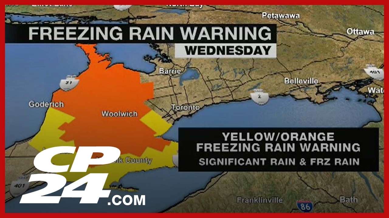
What’s concerning is the impending transition from rain to a mix, expected to occur around 8:39 a.m. in Toronto. An orange freezing rain warning is already in effect for Midwestern Ontario, while a winter storm warning encompasses the city itself. As temperatures drop—as they are expected to—accumulation of wintery mix will likely lead to hazardous road conditions, most notably black ice coated with a thin layer of snow. These conditions could become particularly dangerous during morning commutes.
To combat these challenges, city maintenance crews have already been deployed to treat major roadways with brine and salt. This proactive approach is especially effective during daylight hours, improving traction and lowering water’s freezing point. However, secondary roads and residential sidewalks—often neglected—can quickly become perilous. Residents are encouraged to take preventive measures by applying rock salt in advance of the storm to safeguard personal walkways.
As more winter precipitation approaches, keeping an eye on roadways becomes increasingly necessary. While major arteries currently show no major incidents, elements like mist and rain have already created some delays on routes like the Southtown Valley Parkway, highlighting the need for caution. Awareness and patience will be critical today, as delays might escalate as weather conditions shift.
In parallel, public transportation systems are on alert. The Toronto Transit Commission (TTC) has been proactive in addressing potential weather impacts. Crews have treated streetcar and subway lines overnight, ensuring that services remain operational. With all five subway lines functioning as planned so far, TTC’s staff are present at stations to assist commuters. However, it is worth noting that a medical emergency has temporarily halted streetcar service along the Dundas route. Commuters in that area are advised to allow extra travel time.
In the face of changing weather, staying informed through local news updates will be invaluable. Utilizing resources such as the TTC’s real-time alerts on X, as well as monitoring traffic reports, can help mitigate the stresses of winter commuting.
As the storm unfolds, adaptability emerges as a crucial virtue for residents navigating the streets of Toronto and surrounding areas. While conditions may appear manageable now, the potential for icy roads and hazardous weather looms. Preparation and awareness will go a long way in ensuring safety during this transformative winter weather event. Stay tuned for more updates as the situation develops.