
Weather Outlook: A Transition from Rain to Cold
The city’s skyline, shrouded in low clouds and wind, sets an atmospheric scene as the new weather system approaches. If you’re not yet experiencing rain, don’t let the calm deceive you. Remember to grab your umbrella before stepping out, as inclement weather looms just around the corner.
Current temperatures stand at a chilly 2°C, setting the stage for a significant shift in conditions. Rain is anticipated to move in soon, lingering through the midday hours. As the day progresses, expect a brief respite from the showers, only to be replaced by cooler air that will sweep in this evening. That cooler air will transition the rain into mixed precipitation and flurries, particularly noticeable as night falls.
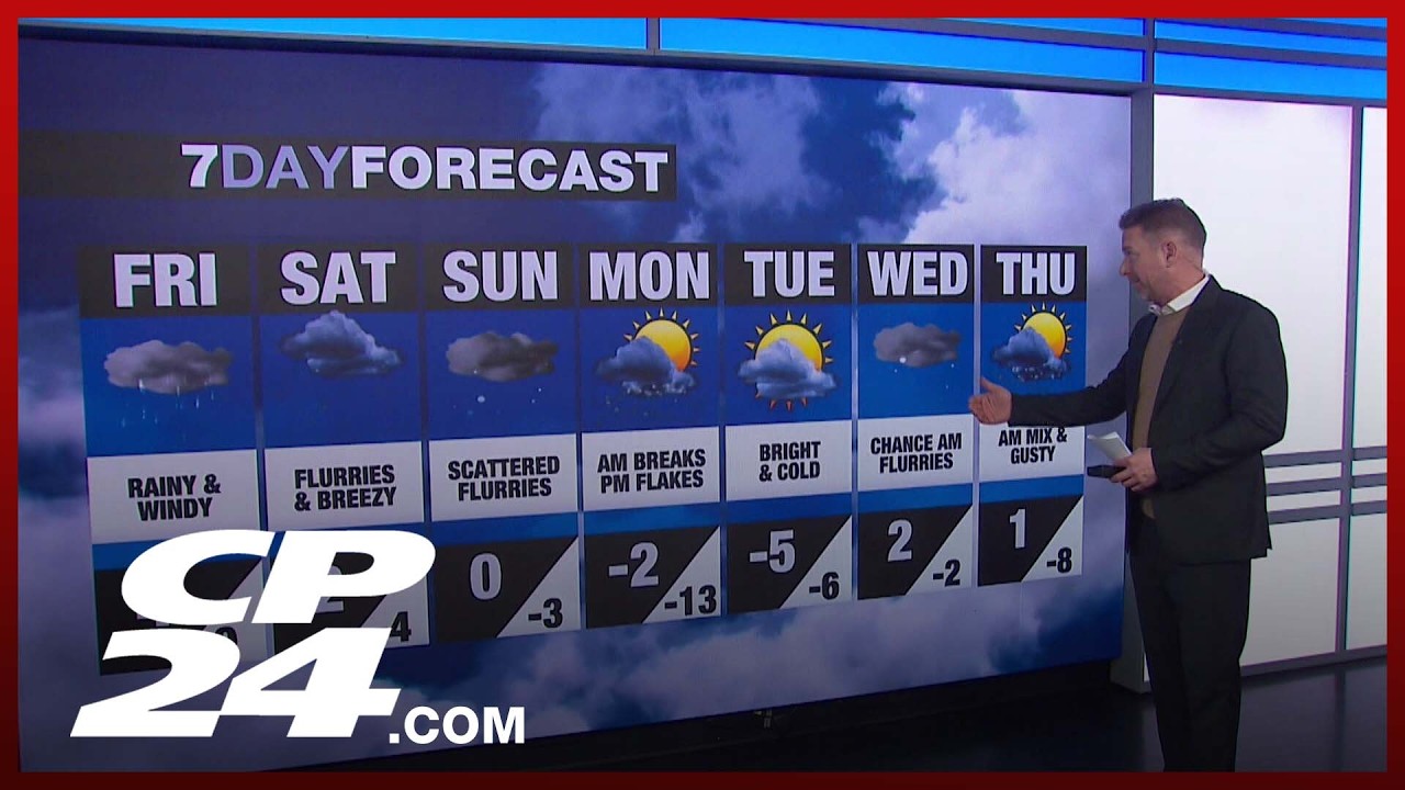
The weather dynamics are influenced by cold air masses currently held captive in the prairies. This frigid air is set to make its presence felt by early next week, with temperatures plummeting to a more biting chill. However, today’s forecast indicates it will be the warmest day of the week, with a high of 4°C before the temperature begins to retreat.
As we observe the current radar, rain appears to be advancing across southwestern Ontario, notably the Niagara region. This precipitation is expected to sweep from southwest to northeast, reaching peak intensity during the morning commute hours between 8:30 AM and 11:30 AM. By 1 PM, we anticipate a lull in the downpour.
The transition from rain to snow is depicted vividly on the meteorological mosaic, where green signifies rainfall and blue highlights areas of snowfall. This duality in precipitation reflects a complex weather system that will continue into the weekend. Although the moisture will persist, it is not expected to lead to heavy accumulations, which means the roads could become slick but manageable.
Looking ahead, the forecast reveals a chilling prospect for Saturday and Sunday. Flurries will persist as the weekend rolls on, leading into early next week. The combination of rain and snow may create hazardous driving conditions, emphasizing the need for caution. While the precipitation might be light, any accumulation could create patches of ice, particularly in shaded areas.
Monday night promises a more drastic shift in weather as temperatures are expected to undergo a significant drop. By Tuesday morning, feel ready for a brisk start to the day with wind chills potentially reaching minus 20°C. The stark change in temperatures signals that winter is still in full force, despite the temptation of a recent warm day.
However, after the biting cold of Tuesday, there is hope for some moderation. As we transition towards the middle and end of next week, the forecast hints at rising temperatures, with daytime highs nudging just above the freezing mark. An intriguing pattern emerges, suggesting slight chances of morning flurries on Wednesday, keeping winter’s presence lingering.
As we approach the beginning of March, the prospect of more mild days may emerge, but fluctuations in temperature are anticipated. This variability is a hallmark of transitional seasons, reminding us that winter’s grip can still exert its influence even when spring is on the horizon.
In summary, prepare for a multifaceted weather pattern over the coming days, starting with rain that turns to mixed precipitation and flurries. Whether you’re braving the wet conditions today or gearing up for a cold snap next week, staying informed and prepared is key. Embrace the pace of shifting seasons; it’s a dynamic ride filled with surprises.